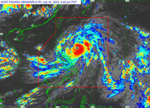
DOKSURI, a tropical storm building over the sea to the east of the Philippines, is set to become a super typhoon as it hurls toward the coast of southern China, potentially making initial landfall in Taiwan.
The maximum wind speed near Doksuri’s eye could reach super typhoon levels of 58 meters per second, or 209 kilometers per hour (kph), as the storm approaches the southern coast of Taiwan, China’s Meteorological Administration said on Monday.
With their destructive winds, monster storms like super typhoons can uproot trees, down power lines and shatter windows, while accompanying storm surges inundate cities and wreak havoc on infrastructure.
Locally named Egay, the typhoon has rapidly intensified while moving westward over the Philippine Sea, the state weather bureau said on Monday morning, as it raised storm signals on the main islands of Luzon and the Visayas.
The typhoon was located 525 kilometers east of Bale in Aurora province as of 10 a.m., according to an 11 a.m. bulletin from the Philippine Atmospheric, Geophysical and Astronomical Services Administration (PAGASA).
It was moving slowly with maximum sustained winds of 150 kph near the center and gustiness of up to 185 kph.
Egay, the fifth cyclone to hit the Philippines this year and the second in July, developed into a typhoon at 11 p.m. on Sunday.
“Egay is forecast to continue intensifying and reach super typhoon category by late tomorrow or on early Wednesday,” the state weather bureau said, as it raised wind signals in some parts of Luzon and the Visayas.
Tropical cyclone wind signal No. 2 was raised over Catanduanes, the eastern portions of Isabela, Albay, Aurora and Quirino, the eastern and central portions of Cagayan, the northern portion of Camarines Norte and Northern Samar.
Wind signal No. 1 was up in Sorsogon, the rest of Albay, Camarines Sur, Cagayan including Babuyan Islands, Apayao, Abra, Kalinga, Mountain Province, Ifugao, the rest of Quirino, Nueva Vizcaya and Batanes.
Also under signal No. 1 were Masbate including Ticao Island, Burias Island, Quezon including Polillo Islands, the rest of Aurora, Benguet, Ilocos Sur, Ilocos Norte, La Union, Nueva Ecija, Pangasinan, Tarlac, Zambales, Bulacan, Pampanga, Bataan, Marinduque, Cavite, Metro Manila, Rizal, Laguna, the eastern and central portions of Romblon and the northern and central portions of Batangas province.
It was also raised in some areas of the Visayas including Eastern Samar, the rest of Northern Samar, Samar, Biliran, the northern and central portions of Leyte, and the northern portion of Cebu including Bantayan Islands and Camotes Islands.
Monsoon rains were expected over the western portions of Central Luzon and the Visayas in the next three days.
Based on PAGASA’s forecast track, Egay was expected to cross the Luzon Strait and make landfall or pass very close to Babuyan Islands and Batanes between Tuesday late evening and Wednesday afternoon.
“A further shift in the forecast closer to Luzon remains a possibility due to the persistence of the ridge of high pressure north of the typhoon,” PAGASA said.
“This is represented by the forecast confidence cone. As such, a landfall over the northeastern portion of mainland Cagayan is not ruled out,” it added.
Egay is expected to leave the Philippine area of responsibility by Thursday as it moves over the waters southwest of Taiwan. — Sheldeen Joy Talavera with Reuters

