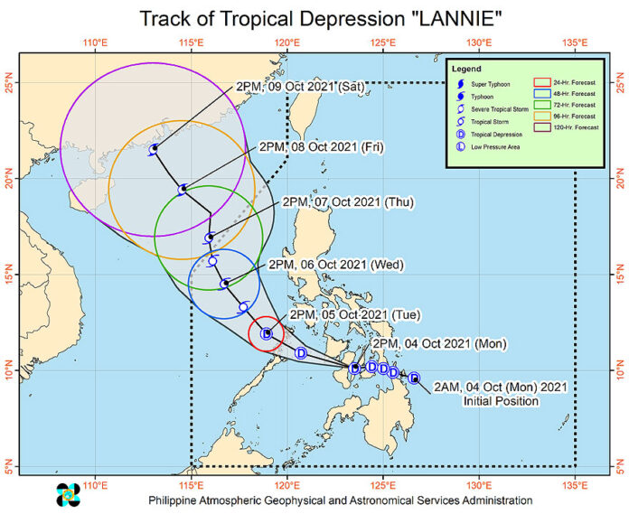
STATE WEATHER bureau PAGASA warned against landslides and flooding as tropical depression Lannie was expected to bring heavy rains over central parts of the Philippines until Wednesday.
As of Monday 5 p.m., Lannie made eight landfalls within a 15-hour period with two each in the northern part of Mindanao, Southern Leyte, and Bohol, and one each in Negros Oriental and Cebu.
PAGASA weather forecaster Ariel Rojas, in a briefing Monday morning, said
Lannie, the 12th typhoon to enter the country this year, was likely to make more landfalls as it moves slowly over the Visayas islands and Palawan.
Lannie was forecast to remain within tropical depression category, with a possibility of slight intensification once it is over the Sulu Sea or West Philippine Sea.
“It may likely be upgraded into a tropical storm by Tuesday evening or Wednesday early morning,” the Philippine Atmospheric Geophysical and Astronomical Services Administration (PAGASA) said.
PAGASA Administrator Vicente B. Manalo called on the public and emergency response teams to maintain vigilance despite the tropical depression category, the lowest within the tropical cyclone intensity scale with just up to 61 kilometers per hour (kms/hr) of sustained winds.
Mr. Manalo said Lannie is still a typhoon and it will bring rains that could trigger flashfloods and landslides, especially in high-risk areas and those that have already been experiencing monsoon rains in previous weeks.
“Wag tayo mag-kumpyansa (Let us not let our guards down) because it will bring heavy rains,” he said.
As of PAGASA’s 5 p.m. bulletin on Monday, Lannie was located in the vicinity of Guihulngan, Negros Oriental with maximum sustained winds of 45 kms/h near the center and gustiness of up to 55 kms/h.
Typhoon signal #1 was up over parts of the provinces of Mindoro, Masbate, Romblon, and Palawan, and most areas of the Central and Western Visayas regions.
Lannie is expected to exit the Philippine area on Thursday morning. — MSJ

