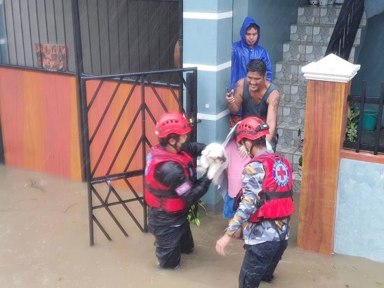
AT LEAST 12 fishermen are missing and 10,976 people were evacuated in the central-eastern parts of the country due to typhoon Jolina (international name: Consom), the national disaster management agency reported Wednesday.
Those missing from Catbalogan City in Samar “went fishing despite warning/advisory from the local authorities not to venture at sea,” the National Disaster Risk Reduction Management Council said in its Sept. 8 report.
Meanwhile, the severe tropical storm brought heavy rains in parts of Luzon on Wednesday, including Metro Manila, where several areas were flooded.
Evacuations were reported in the provinces of Cavite and Batangas, and in Quezon City in the capital region. Other areas such as Marikina City were also ready for the possible evacuation of residents.
The National Water Resources Board (NWRB) said rains brought by Jolina replenished the water level of Angat Dam, bringing it to 194.44 meters as of Wednesday morning.
“Amid the increase, the current water level of 194.44 meters is still far from our target of 212 meters before the year ends in order to ensure water supply for the irrigation uses of farmers,” NWRB Executive Director Sevillo D. David, Jr. said in a television interview.
State weather bureau data as of Wednesday morning showed that Angat Dam’s water level rose by 55 centimeters compared to 193.89 meters recorded the day before.
Mr. David said the rains allow dams such as Angat to recharge its water level for uses such as irrigation, hydropower, and water supply for Metro Manila.
Meanwhile, the corporate office of the Metropolitan Waterworks and Sewerage System (MWSS) announced in a social media post that it gradually opened the radial gates of Ipo Dam due to the rains brought by Jolina.
MWSS said that as of 8 a.m. Wednesday, Ipo Dam’s radial gate number 1 was 15 centimeters to 20 centimeters open, releasing 47 cubic meters per second of water to the Angat River.
State weather bureau data as of Wednesday morning indicated that the water level of Ipo Dam was at 101.23 meters, above its normal high-water level of 101 meters.
“Ipo Dam which receives water from the Angat Dam and diverts water to La Mesa Dam had to spill to avoid being overtopped. MWSS has issued a notice to local governments today about the planned spill release in order to alert residents in low-lying areas,” it said.
“Residents are advised to exercise extra caution due to the possibility of the river flowing up to the tops of the banks,” it added.
Meanwhile, the Department of Energy (DoE) announced that three dams under the National Power Corp. have been undergoing spilling operations as of Wednesday morning amid the onslaught of Jolina.
In a task force on energy resiliency update, the DoE said the Ambuklao, Binga and Agus 4 dams were releasing water as part of ongoing spilling operations. All other NPC-run dams were tagged as “normal,” meaning they were not undertaking spilling operations.
DAMAGE
The agricultural damage caused by severe tropical storm Jolina was initially assessed at P179.57 million, according to the Department of Agriculture (DA).
Based on a bulletin issued by its Disaster Risk Reduction and Management Operations Center on Wednesday noon, the DA estimated that a total of 61,828 farmers were affected by the typhoon.
Damage to rice reached 8,855 metric tons (MT) of production loss and affected 52,609 hectares of farm areas. The bulletin did not have figures yet on losses to other crops and subsectors.
“These values are still subject to validation,” the DA said.
State weather agency PAGASA, in its 5 p.m. bulletin, said Jolina was located in the vicinity of San Nicolas in Batangas. It was packing maximum sustained winds of up to 95 kilometers per hour (kms/h) and gustiness of 160 kms/h, with strong winds extending outwards up to 180 kms from the center.
Typhoon signal #2, which indicates damaging gale-force to storm-force winds, was up in most parts of the Calabarzon Region and Mindoro provinces, Metro Manila, and the provinces of, Bulacan, Pampanga, Bataan, Zambales, and Tarlac. Signal #1, meanwhile, was hoisted over Marinduque, Pangasinan, and Nueva Ecija.
By Thursday morning, the typhoon is forecasted to be 205 kms west of Dagupan City in Pangsinan. It is expected to be out of the Philippine area by Friday morning.
Another typhoon that entered the country Tuesday afternoon, with international name Chanthu and locally named Kiko, is expected to bring heavy rains in the extreme northern parts of the country by Friday.
PAGASA said typhoon Kiko slightly intensified Wednesday as it moved in a southwest direction over the Philippine sea with maximum sustained winds of 155 kms/h and gustiness of up to 190 kms/h. — Marifi S. Jara and Revin Mikhael D. Ochave

