

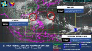

Two low-pressure areas (LPAs) and a tropical depression are being monitored as the southwest monsoon continues to threaten Luzon and Visayas, according to the Philippine Atmospheric, Geophysical and Astronomical Services Administration (PAGASA) on Tuesday.
Both of the LPAs have a high chance of developing into a tropical depression within the next 24 hours, PAGASA said in its 10:00 a.m. tropical cyclone monitoring.
The nearer LPA was located 400 kilometers (km) West of Calayan, Cagayan, outside of the Philippine Area of Responsibility (PAR).
The farther and recently developed LPA was spotted 1,170 km East of Extreme Northern Luzon.
PAGASA was also monitoring a tropical depression outside PAR, located exactly at 3,160 km East of Northeastern Mindanao.
PAGASA is expected to provide new updates about the disturbances by 5:00 p.m.
Meanwhile, PAGASA said as of 11:00 a.m. that the southwest monsoon, which triggered widespread flooding in Metro Manila and nearby areas on Monday, will still bring up to intense rainfall in several areas, posing risks of flooding events and landslides.
Intense rainfall, or 100 to 200 millimeters (mm) of rainfall, is expected to downpour over Zambales, Bataan, Cavite, Batangas and Occidental Mindoro.
PAGASA warned of possible flooding events in urbanized, low-lying, and near-river areas under this rainfall condition.
Areas of Metro Manila, La Union, Benguet, Pangasinan, Ilocos Sur, Abra, Tarlac, Pampanga, Bulacan, Nueva Ecija, Laguna, Rizal, Oriental Mindoro and Antique will experience heavy rains, or rainfall between 50 to 100mm.
Under these rainfall conditions, localized flooding is likely, especially in urbanized, low-lying and near-river areas.
PAGASA said that similar areas are still expected to experience heavy downpours until Friday noon. — Edg Adrian A. Eva