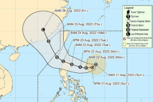
TROPICAL depression Florita is expected to bring heavy to intense rains in the eastern side of central and northern Luzon, the Philippine’s northern mainland, starting late Monday to Tuesday evening, state weather bureau PAGASA said on Sunday.
Florita, the 6th typhoon to enter the country this year, is seen to intensify into tropical storm category within the next 36 hours, the Philippine Atmospheric, Geophysical and Astronomical Services Administration (PAGASA) said in its 11 a.m. bulletin.
It is forecast to make landfall in the vicinity of Cagayan or northern portion of Isabela on Tuesday morning or afternoon.
“Under these conditions, scattered to widespread flooding (including flash floods) and rain-induced landslides are expected especially in areas that are highly or very highly susceptible to these hazards,” PAGASA said.
PAGASA also warned owners of small boats not to venture out in the eastern seaboard of northern Luzon.
Based on the track forecast, Florita was expected to be about 545 kilometers (km) east of Casiguran, Aurora by Sunday evening.
It will move north-westward towards the provinces of Isabela, Ilocos Norte, and Cagayan until Wednesday.
It is seen to be out of the Philippine area by Thursday morning at 505 km northwest of Itbayat, Batanes. — MSJ

