

LPA develops into tropical depression; easterlies to drench Batanes, Babuyan — PAGASA – BusinessWorld Online

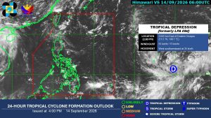
The low-pressure area (LPA) outside of the Philippine Area of Responsibility (PAR) has developed into a tropical depression, while the easterlies may bring thunderstorms over Batanes and Babuyan Islands, posing a risk of flooding and landslides, according to the state weather bureau on Monday.
The tropical depression developed at around 2:00 p.m. and was last located 2,645 kilometers East of Eastern Visayas, packing 55 kilometers per hour (kph) of maximum sustained winds and 75 kph of gustiness, the Philippine Atmospheric, Geophysical and Astronomical Services Administration (PAGASA) said in its 5:00 p.m. press briefing.
“In the next few days, it is possible to move north-westward. If that happens, we are not removing the possibility that it may enter PAR,” Charmagne Varilla, PAGASA weather specialist, said in a press briefing in Filipino.
The weather disturbance is currently moving West-southwestward at 35 kph, and if it enters PAR, it will be given a local name, Queenie, the country’s 17th tropical cyclone this year.
“It has a low chance of making landfall or affecting any parts of the country,” Ms. Varilla said.
Meanwhile, easterlies are forecast to cause thunderstorms over Batanes and Babuyan Islands in the next 24 hours, posing a risk of flooding and landslides during severe thunderstorms, PAGASA said in a separate 4:00 p.m. weather forecast.
In Metro Manila and the rest of the country, generally fair weather is expected, but localized thunderstorms may still occur, especially during the afternoon on Tuesday.
PAGASA also warned of the chance of flooding and landslides during severe thunderstorms in these areas. — Edg Adrian A. Eva