

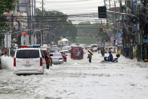

The Southwest Monsoon, or Habagat, continues to bring heavy rains over Metro Manila and parts of Luzon, with flooding reported across several areas of the capital as rainfall intensified on Monday.
The situation also highlights the importance of understanding PAGASA’s color-coded rainfall warnings, which are meant to guide communities on when to stay informed, prepare for possible flooding, or take immediate action.
PAGASA uses three levels of heavy rainfall warnings: yellow, orange and red.
A yellow rainfall warning means heavy rains are being observed or expected, with rainfall of 7.5 millimeters (mm) to 15 mm in an hour that may continue for the next two hours. At this level, flooding is possible, particularly in low-lying areas and near river channels.
An orange warning covers rainfall of more than 15 mm to 30 mm within an hour, continuing for the next two hours. Flooding and landslides are likely at this level, and residents should be prepared to take necessary action, including possible evacuation.
A red warning is the highest level, covering rainfall of 30 mm or more within an hour. Severe flooding and landslides may occur, while roads can become flooded and impassable. Authorities may need to implement emergency measures, including preemptive or mandatory evacuation.
Monday’s rainfall showed how quickly conditions can deteriorate.
The Metropolitan Manila Development Authority said 201.7 mm of rain was recorded yesterday, August 17, at the Science Garden Station in Quezon City in just five hours from 9 a.m. to 2 p.m.
The MMDA has noted that 138 mm fell between noon and 2 p.m., causing water levels to rise rapidly and flooding several roads across Metro Manila.
The MMDA compared the rainfall with Tropical Storm Ondoy, which brought 455 mm of rain in 24 hours in September 2009 and caused widespread flooding across the region.
By 6:20 p.m. of August 17, the MMDA had reported flooding ranging from gutter-deep to tire-deep in several areas of Manila, Quezon City, Malabon and other parts of the capital.
In Manila, floodwaters reached 24 inches at España Boulevard corner M. Dela Fuente Street, making the road impassable to all vehicles. España Boulevard corner Antipolo Street also recorded 17 inches of flooding and was closed to light vehicles.
Other affected roads included Rizal Avenue, Abad Santos Avenue and several major roads in Quezon City.
In Quezon City, flooding at A. Bonifacio Cloverleaf reached 26 inches, while portions of Araneta Avenue, Quezon Avenue, EDSA White Plains and other roads were also reported impassable to some vehicles.
Malabon also saw flooding along Gov. Pascual Avenue, F. Sevilla Boulevard and other streets.
The MMDA deployed flood control teams and continued monitoring major roads through CCTV cameras as authorities responded to the flooding.
THE RAINS WERE ALREADY IN THE FORECAST
The heavy rains were not entirely unexpected.
In its weekly outlook issued on August 14, PAGASA said the Southwest Monsoon could continue to bring occasional to frequent rains from August 16 to 19 over La Union, Pangasinan, Abra, Benguet, Zambales, Bataan, Cavite, Batangas and Occidental Mindoro.
For Metro Manila and the rest of Luzon, PAGASA forecast cloudy skies with scattered rains and thunderstorms. Western Visayas was also expected to experience cloudy skies with scattered rains and thunderstorms, while the rest of the country was expected to have partly cloudy to cloudy skies with isolated rain showers or thunderstorms.
PAGASA also expected the Habagat to continue affecting Metro Manila and the rest of Luzon on August 20 and 21, with cloudy conditions and chances of scattered rains and thunderstorms.
The latest conditions therefore generally matched the direction of the earlier forecast: the habagat remained active, and Metro Manila continued to experience rain.
INTENSITY IS A DIFFERENT QUESTION
While the August 14 forecast correctly anticipated continued wet weather, it did not specify the amount of rainfall that Metro Manila would eventually receive on Monday.
This is an important distinction when assessing the accuracy of a weather forecast.
A weekly outlook provides a broader picture of expected weather conditions over several days. It does not necessarily indicate the exact amount of rain that will fall in a specific location or the precise streets that will flood.
The August 14 forecast expected scattered rains and thunderstorms over Metro Manila. The actual rainfall in Quezon City, however, reached 201.7 mm in five hours, including 138 mm in just two hours.
This means the broader forecast was consistent with what eventually happened, but the actual rainfall intensity was much greater than what a general weekly outlook could convey.
That is where PAGASA’s rainfall warnings become particularly important.
The weekly forecast gives residents an early indication that wet weather is likely. The color-coded warnings provide more immediate information when rainfall intensifies and crosses specific thresholds.
MORE RAINS EXPECTED
PAGASA’s latest five-day regional weather outlook, issued at 9 a.m. on August 18, shows that the Habagat will continue to influence Metro Manila and nearby provinces through August 22.
For Metro Manila, moderate to strong southwest winds are expected throughout the forecast period. The capital may experience partly cloudy to at times cloudy skies with rain showers and thunderstorms, followed by cloudy skies with rain showers or thunderstorms.
Nearby provinces are also expected to remain under similar conditions.
Cavite is forecast to experience partly cloudy to cloudy skies with rain showers and thunderstorms, while Batangas and Zambales are expected to continue experiencing moderate to strong southwest winds. Coastal waters in these areas may also remain moderate to rough.
Rizal and Quezon are likewise expected to experience moderate to strong southwest winds through the forecast period.
For communities in flood-prone areas, the continuing wet conditions mean that Monday’s flooding should not necessarily be treated as the end of the threat.
Residents should continue monitoring PAGASA and local disaster officials, particularly when rainfall becomes persistent or intensifies.
The distinction between a forecast and a rainfall warning is crucial. A forecast tells people what weather conditions are likely to prevail, while a rainfall warning signals that rain has reached a level that may require immediate preparation or response.
As the habagat continues, the practical message remains simple: yellow means be aware, orange means prepare, and red means take action.
With more rain expected over Metro Manila and parts of Luzon in the coming days, staying updated on the latest rainfall warnings could make the difference between having time to prepare and being caught in rapidly rising floodwaters. — Kaizzer Angela Marie V. Manuba