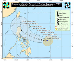
A LOW-pressure area that developed into a tropical depression Wednesday morning is expected to strengthen into a storm by Thursday, according to the state weather bureau.
“Further intensification is likely while moving over the Philippine Sea and may reach typhoon category on Saturday,” PAGASA said in its 5 p.m. bulletin on Wednesday.
Tropical depression Paeng, the 16th typhoon to enter the country this year, dumped heavy rains in central parts of the Philippines on Wednesday, with floodings reported in several areas by local authorities.
Several local governments in the regions of Central and Eastern Visayas declared a suspension of classes Wednesday based on high rainfall warnings issued by PAGASA.
The center of Paeng was located 945 kilometers (km)east of Eastern Visayas as of Wednesday afternoon.
It was moving westward with maximum sustained winds of 45 km per hour (km/h) and gusts of up to 55 km/h.
Tropical cyclone wind signals may be hoisted for some areas in Eastern Visayas and Bicol Region by Thursday morning, PAGASA said, noting that wind signal #4 in a 5-level system is possible in the coming days.
“A landfall scenario in northern Luzon is not ruled out,” it added.
Sea travel could be affected over the weekend, the bureau said.
On Thursday, the combined effects of the northeast monsoon and the approaching tropical cyclone may also bring moderate to rough seas over the eastern seaboards in the Visayas and Mindanao, the central and southern parts of the Philippines. — MSJ

